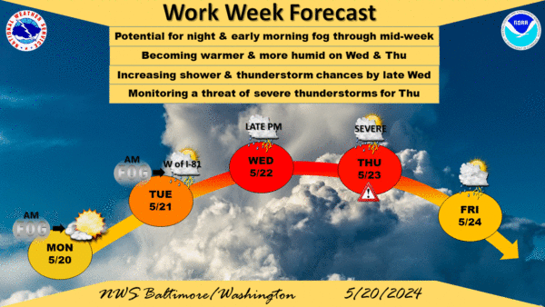

As the busy Memorial Day travel period begins, travelers should be aware of the risk of severe weather on Thursday, May 23, and Friday, May 24. A deep upper trough tracking across Quebec will bring a series of lower amplitude waves to the Mid-Atlantic region. A slow-moving cold front is expected to push through the area from midday into the evening hours on Thursday, according to the National Weather Service.
Weather conditions will be ripe for severe thunderstorms.
On Thursday, the day will be warm with highs in the mid to upper 80s and heat indices approaching the low 90s due to persistent south-southwesterly winds. As the cold front moves through, the threat of showers and strong to severe thunderstorms will be present. Travelers should monitor weather updates as cloud cover trends, which can inhibit convective potential, will play a critical role, the weather service states.
By Friday morning, the frontal boundary is expected to slide southward, leading to a slight drop in temperatures and dew points. However, the risk of showers and thunderstorms will return later in the day as the boundary re-approaches the area from the south. This unsettled weather pattern is expected to persist into the weekend, with daily chances of showers and thunderstorms continuing. Travelers are advised to stay updated on weather forecasts and plan accordingly.
Today, we’ll see early-morning fog which will lift across the region, and then becoming mostly sunny this afternoon. High pressure will keep the area dry, with any low chances for showers likely staying west of the Appalachians. High temperatures are expected to reach the upper 70s to lower 80s today. Low temperatures tonight will fall into the 50s, with some patchy fog or low clouds possible once again overnight.