Image may be NSFW.
Clik here to view.
Clik here to view.
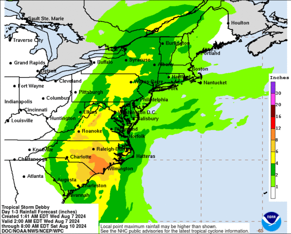
Image may be NSFW.
Clik here to view.
The National Weather Service has issued a forecast indicating that Tropical Storm Debby will significantly impact our region with heavy rain and potential flooding. Residents should prepare for various weather conditions over the next few days.
Wednesday:
- Morning to Early Afternoon: Expect mostly dry conditions, with temperatures reaching the mid- to upper 80s in lower elevations and the upper 70s in the mountains.
- Late Afternoon to Early Evening: Showers and thunderstorms are expected to develop, increasing the risk of isolated flooding due to recent rainfall and partially saturated soil east of the Blue Ridge.
Overnight into Thursday:
- Showers and storms will persist overnight, with lows in the 70s near the waters and 60s further north and west. Winds will pick up, with gusts of 10 to 15 mph possible.
Thursday to Friday Night:
- Thursday: The remnants of Debby will begin to affect the area. Rainfall will start light to moderate, increasing by evening as Debby moves northward. The exact track remains uncertain, but expect a prolonged moderate to heavy rainfall from late Thursday night into Friday.
- Friday: The impact will depend on Debby’s track. Rainfall amounts could range from 3 to 7 inches, with localized areas receiving up to 10 inches, especially in central Virginia. Areas further north and east might see 2 to 4 inches, with localized areas up to 7 inches.
Weather Threats:
- Flooding: Due to the expected rainfall totals, a flood watch may be issued, particularly if heavy banding sets up over specific areas.
- Tornadoes: A conditional threat exists for tornadoes, particularly east of the storm’s center.
- Wind: Gusts of 20 to 30 mph are expected, with stronger gusts possible in thunderstorms, particularly on the eastern side of Debby’s circulation.
Conclusion:
- The remnants of Debby will continue to move northeast Friday night into Saturday morning, with impacts subsiding by Saturday. Overnight lows will range from the upper 50s along the Allegheny Front to the 60s and low 70s toward the waters.
The City is preparing for the potential impacts from Tropical Storm Debby.
Here is how you can prepare:
-Clear your outdoor drains & ensure that your sump-pump is working.
-Secure outdoor furniture.
-Sign up for Emergency Alerts from the City by going to: https://t.co/bFiH4If4Wn— CityofManassasPark (@ManassasParkGov) August 7, 2024