
The region will experience severe weather conditions today, with scattered clusters of showers and thunderstorms approaching from central West Virginia. These storms have the potential to cause flash flooding.
According to the National Weather Service, some storms may result in damaging winds, especially in the most intense storm cores near and east of Interstate 95. Heat and humidity remain factors, with today’s temperatures slightly cooler than Friday due to increased cloud cover. No heat advisories have been issued, but the highest heat indices are expected near the Chesapeake Bay.
Conditions are expected to clear gradually overnight, though the stagnant, humid air and trough axis overhead could lead to additional showers or thunderstorms.
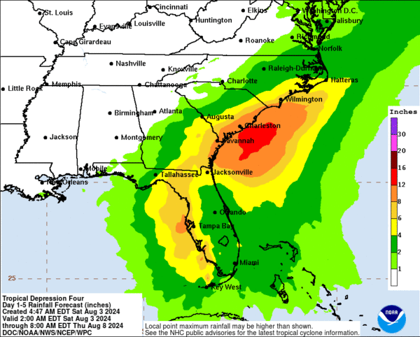
Tropical Depression
A tropical depression is anticipated to drift along the Mid-Atlantic coast late next week, bringing relief from the recent high temperatures.
The extended forecast shows a trend towards drier conditions on Tuesday, although hot and humid weather will persist. By mid to late week, another front will increase the chances of showers and thunderstorms. The track of the tropical depression is expected to parallel the southeast U.S. and Mid-Atlantic coast, likely bringing beneficial rainfall to areas experiencing drought conditions.
As the system progresses, highs will reach the upper 80s and low 90s on Tuesday before cooling to the mid to upper 80s midweek. Some models predict temperatures in the upper 70s and low 80s on Thursday and Friday due to increased cloud cover and rain chances from Tropical Depression 4. Overnight lows will fall into the 60s, with cooler temperatures in the mountains.
High pressure will return following the system, bringing more stable conditions for the next weekend.