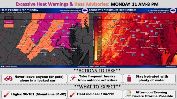

An excessive heat warning is in effect from 11 a.m. to 8 p.m. on Monday, and an excessive heat watch remains in effect from Tuesday morning through Tuesday evening.
The warning indicates dangerously hot conditions with heat index values around 110 expected. The watch forecasts possible heat index values up to 110.
The areas affected include portions of central, northeast, northern, and southern Maryland, the District of Columbia, and central and northern Virginia.
During the warning period on Monday, extreme heat and humidity will significantly increase the potential for heat-related illnesses, particularly for those working or participating in outdoor activities. The conditions are expected to persist into the overnight hours. It is essential to stay hydrated and find ways to stay cool.
High temperatures are predicted to reach around 100 degrees, especially along and east of the Blue Ridge. The excessive heat warning has been upgraded for the Washington, D.C., and Baltimore metro areas and the northern portions of the Shenandoah Valley into the eastern panhandle of West Virginia. Heat advisories are in effect for other areas tomorrow afternoon and evening.
Showers and thunderstorms are possible in the afternoon and evening on Monday. The severity of the storms is uncertain. According to the National Weather Service, the Storm Prediction Center has the area at a Level 1 out of 5 for severe weather risk on Monday.
An excessive heat watch was issued for most of the area for Tuesday, excluding the Blue Ridge and Alleghenies. Heat indices between 100 and 110 degrees Fahrenheit are likely. Showers and thunderstorms are possible again, though the coverage is more uncertain than Monday. Overnight lows will range from the upper 60s to low-to-mid 70s further east towards the waters.