
The National Weather Service has warned about dangerously hot conditions in the region through the weekend. High pressure will remain offshore, and the current weather pattern will be maintained until Monday.
High pressure is centered offshore with upper-level ridging in place. Temperatures are expected to reach the mid-90s for most areas, with mid-to-upper 80s in the mountains. Terrain-driven circulations may cause thunderstorms this afternoon over the Allegheny Front and Potomac Highlands, but conditions will remain dry further east. Any storms will dissipate this evening, leading to overnight lows in the low to mid-70s for most areas and upper 60s in the mountains.
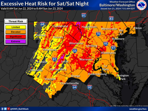
Looking ahead to Saturday, high pressure will remain offshore. This will draw hot air into the region, pushing temperatures to the upper 90s to near 100. Dewpoints will increase into the upper 60s to lower 70s, resulting in heat index values of 100-110. An Excessive Heat Watch is in effect for much of the area on Saturday afternoon.
A surface trough is expected to develop, leading to showers and thunderstorms in response to daytime heating. Any storms will dissipate after dark, with overnight lows in the mid-to-upper 70s and possibly lower 80s.
On Sunday, high temperatures will reach the mid-to-high 90s, with heat index values of 100-110 east of the Blue Ridge. Thunderstorms are possible Sunday afternoon into Sunday night, with severe storms capable of producing damaging winds. The Storm Prediction Center has placed much of the area at a marginal risk for severe thunderstorms on Sunday.


