
Bitterly cold air is sweeping into the region, but the anticipated snowstorm will largely miss Northern Virginia. Instead, it will track south toward Williamsburg and Virginia Beach, where accumulations are expected to be significant.
According to the National Weather Service, an expansive Arctic high-pressure system is building into the north-central U.S., reinforcing the cold snap. Meanwhile, an area of low pressure developing over the Mississippi River Valley will move toward the Carolinas before heading offshore midweek. As a result, the heaviest snowfall will stay well to the south, sparing much of Northern Virginia, the Washington, D.C. area, and Maryland from significant impacts.
Frigid Temperatures Settle In
Though the region will miss the brunt of the snowstorm, the incoming Arctic air will make for a bitterly cold stretch. Low temperatures will dip into the single digits across higher elevations, with wind chills dropping to -10 to -15 degrees west of the Allegheny Front. Due to dangerously low wind chills, a Cold Weather Advisory is in effect for those areas.
Elsewhere, temperatures will fall into the mid-teens to mid-20s, with wind chills in the single digits and teens. While winds have diminished somewhat since the weekend, 20 to 30 mph gusts are still possible Tuesday, adding to the chill.
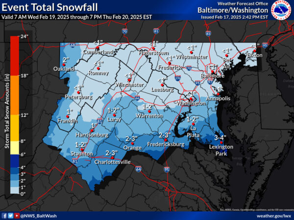
Snow Stays South, But Some Areas May See Flurries
Forecasters say the developing storm system will stay to the south, keeping most accumulating snow out of Northern Virginia and D.C. However, depending on the track and intensity of the system, parts of southern Maryland, particularly St. Mary’s County, may still see snowfall. A Winter Storm Watch has been issued for that area, where up to five inches of snow could fall.
Elsewhere, only a few flurries or light snow showers are possible late Tuesday into Wednesday, but no significant accumulation is expected.
Cold Continues Through the Week
After the storm passes, high pressure will take control, keeping conditions dry but cold through the end of the week. High temperatures will likely remain below freezing across much of the region, with nighttime lows plunging into the teens and single digits.